

Geopark

UNESCO has cooperated closely with the European Geopark Network meeting its strict quality criteria right from the start. Under the auspices of UNESCO, the European Geoparks are now members of the Global Geopark Network on the one hand, and part of the UNESCO World Heritage on the other. Worldwide, there are 140 different Geoparks in 38 countries, most of them in Europe, while others can be found in East Asia, for instance in China or Japan.
Back in 2000, the European Geopark Network was founded by 4 regions. There are currently 73 members in 23 European countries such as Germany, Spain, Great Britain and Italy. In addition to the Styrian Eisenwurzen Geopark, there are three more Geoparks in Austria, one of them in Salzburg and two in Carinthia.
In 2002, the Styrian Eisenwurzen Nature Park was awarded the title of European Geopark and in 2004, it became a member of the Global Geopark Network under the auspices of UNESCO. In 2015, it was recognized as a UNESCO Global Geopark as part of the UNESCO World Heritage.
Further information at
UNESCO Global Geoparks are unified geographical areas where sites and landscapes of international geological importance are managed with a holistic approach to conservation, education and sustainable development. (Source unesco.org) UNESCO Global Geoparks work on different priorities for a region:
- Outreach and geotourism
- Education
- Sustainable tourism
- Research
- Climate change and environment
- Regional development
- Protection of the geological, natural and cultural heritage
For this purpose, various guidelines have to be fulfilled, such as visibility of the Geopark, or regular international exchange, but also research and awareness-raising measures. In addition, there are various external support and scientific advice. Based on years of positive experience we rely on expertises of the Natural History Museum Vienna.

Priv. Doz. Dr. Alexander Lukeneder born. 1972 in Steyr Upper Austria, studied Earth Sciences and Paleontology in Vienna, since 2004 scientist and curator for the Mesozoic collection at the Natural History Museum Vienna, 2016 Habilitation in Paleontology at the University of Vienna, lecturer for lectures at the University of Vienna; focus on Mesozoic (Triassic, Jurassic, Cretaceous), evertebrates, paleoecology, paleoclimate; leader of 4 FWF projects on the Mesozoic; Discovered the first pliosaur in Austria in 2019; authored over 120 scientific and popular articles as Austria’s leading mesozoologist; member of the Geo/Hydro Science National Committee of the Austrian Academy of Sciences; Austrian representative on the Earth System Sciences Science Board of UNESCO in Paris; book author of Dinosaur File, Adventure Dolomites, and Hiking into the World of Dinosaurs; lecturer at children’s universities and Young Science Ambassador. Inventor and operator of the Fossifinder project within the framework of Österreich forscht/Citizen Science.
Homepage: nhm-wien.ac.at/alexander_lukeneder
Univ.-Prof. Dr. Michael Wagreich, born 1960 in Baden near Vienna, studied geology in Vienna, since 1988 scientist and lecturer at the University of Vienna, 2003 habilitation in geology, since 2019 university professor for geology and head of the Institute of Geology at the University of Vienna. Main research interests in the Cretaceous period, a.o.. on paleoclimate and catastrophes in Earth history, and in the recent geologic past, the human-influenced Anthropocene; Chair of the Cretaceous Subcommission of the International Stratigraphic Commission, and member of the Anthropocene Working Group; Leader of global UNESCO International Geoscience Program projects on greenhouse climate and sea level rise, as well as several FWF and WWTF research projects and applied geology projects; author of over 300 scientific articles and studies, including contributions to the highly respected journals Science and Nature; project leader of the science communication project “Students [er]leben Erdgeschichte: Red Chalk”; member of “Scientists for Future Austria”.

A Geopark does not have a distinct degree of protection incorporated in the law, but it hold a title for areas with a particularly rich geological heritage and a strategy for sustainable regional development. A Geopark does not have to focus on its geological potential exclusively, it can also integrate sites of archaeological, ecological and cultural importance creating a link between them via a network.
European and Austrian Geoparks aim to achieve the following goals:
- Raising environmental awareness among the public focusing on geotopics related to a specific area.
- Creating added value on a regional basis by offering sustainable geotourism activities
- Supporting and promoting academic research in the park.
For further information, please go to umweltbundesamt.at.
Austria has two more Geoparks besides the Styrian Eisenwurzen:
-
The Ore of the Alps Geopark in Salzburg Pongau:
geopark-erzderalpen.at -
The Karawanken Geopark near Bad Eisenkappel, Carinthia (Austrian-Slovenian Cross-border Geopark):
geopark-karawanken.at
Downloads


Leaving no Stone Unturned – Introducing Geology
The whole of the Styrian Eisenwurzen Nature & Geopark is nestled in the Northern Limestone Alps. Most of the rocks found here date back to the Mesozoic Era. At the beginning of this era, 253 million years ago, there was only one single giant continent called Pangaea. The stones of the Limestone Alps were formed on the edge of an enormous bay of this giant continent.
Hornstein: hard as glass
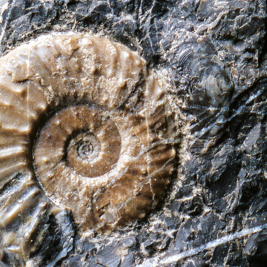
240 million years ago, the sea flooded the landscape shaped by beaches and lagoons. This marked the beginning of the deposition process of limestone and dolostone, e.g. the predominant rocks of the Limestone Alps. The Reifling limestone, named after its occurrence in the Nature & Geopark community Großreiflling, is one of the oldest rocks. The rocks typically occur in the form of irregularly shaped, dark grey chert nodules arousing from the dissolved siliceous skeletons of radiata and sea sponges.
Limestone and dolomite: the backbone of the Limestone Alps
The seabed has been sinking throughout the entire Triassic Era. While it’s true that the sinking only amounted for fractions of a millimetre per year, this happened over a period of 45 million years. However, algae and marine animals lime residues compensated for the sinking, thus, the sea did not get any deeper in the meantime. With the beginning of the Jurassic Era 205 million years ago, the disintegration of the giant continent began. The exchange of deep and shallow parts of the sea has led to a great diversity of rocks deposited. Therefore, the Noth Gorge bears red limestone with numerous remains of sea lilies, animals related to starfish and sea urchins.
The day the Alps were born
Paradoxically, the Alps owe their existence to the advancing disintegration of the giant continent. With the uplift of the Alps, the Limestone Alps began to slip along with the greywacke zone towards the north and northeast. Still under water, the Limestone Alps pushed far above the edge of primeval Europe. During this process, the Limestone Alps broke into sections of different sizes which had often converged over miles. This is what we call the “nappes” of the Alps. One of these nappe boundaries is located at the northern rim of the Gesäuse Mountains.
Sand and clay
135 million years ago, the next era of earth’s history, the Cretaceous Era, and along with it, the rise of the Alps above sea level began. Later, 90 million years ago, an island landscape emerged in the south of the Limestone Alps. At that time, the Limestone Alps were still pushing north. While parts of them went up, others sank over time. In the sinking parts of the mountains, deposits of sand and clay were left behind. One of these reservoirs can be found in Gams.
The Ice Age
The ice age which started about 800 million years ago had a major influence on the landscape. As the glacier receded, the ice melted, and the rising rivers and streams carried huge quantities of rock debris which the glacier ice had left behind with them. As the current subsided, the rocks, e.g. gravels, were deposited filling the entire width of the valley. Due to limestone deposits, gravel cemented into conglomerate. Following a recent ice age which ended 12,000 years ago, the rivers have cut deep valleys into the conglomerate. The rims, which have a flat surface and steep cliffs, form terraces that extend from Hieflau to Großraming in Upper Austria in the Enns valley, and from Fachwerk to the mouth at Großreifling in the Salza valley.
Bibliography:
- Bryda, G., D. van Husen, O. Kreuss, V. Koukal, M. Moser, W. Pavlik, H.P. Schönlaub, M. Wagreich (2013). Erläuterungen zur Geologischen Karte der Republik Österreich 1:50.000, Blatt 101, Eisenerz, 223 pp. Geologische Bundesanstalt Wien
- Husen, D. van (2000). Austrian Geological processesduringtheQuaternary. Mitteilungen der Österreichischen Geologischen Gesellschaft, 92 (AspectsofGeology in Austria), 135 – 196.
- Kollmann, H. A. (1998). Geologie des Gemeindegebiets. In: Meine Heimat. Heimatbuch der Gemeinde Gams: 22 – 30
- Kollmann, H. A. (2009). A Review of the Geology of the Late Cretaceous-Paleogene Basin of Gams (Eastern Alps, Austria). In: The K/T boundary of Gams (Eastern Alps, Austria), A. F. Grachev, Ed. Abhandlungen der Geologischen Bundesanstalt 63: 9 – 13